Anybody Know The Stockport Area Well?

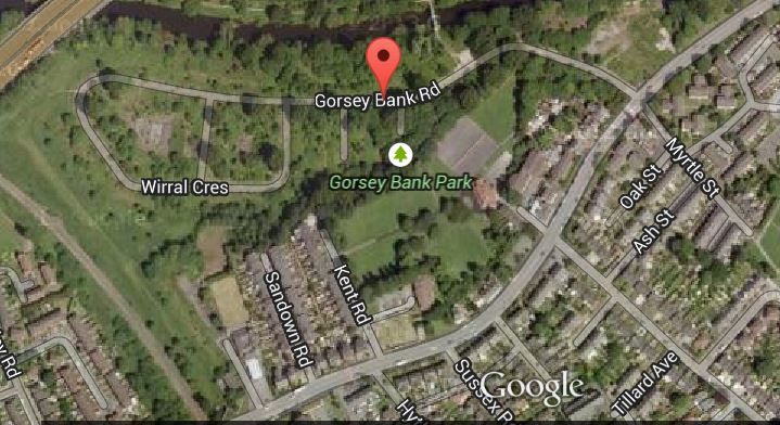
Interested as to why Hoylake Road seems longer than any map ever admits.

It is blocked off by a yellow barrier at the end but you can see it used to continue further.

Oddly of all the roads surrounding the doomed estate, only Hoylake matches the names of the estate in that they are all from the Wirral. Hold up, I hear you shout. Egremont is in Cumbria!

Yes, indeedy it is. But Egremont Promenade is on the Wirral.... ;)

Because of that link, that leads me to believe the road was originally connected with the estate and perhaps meant to link into it.

It is in direct line with Wirral Crescent.


Terry, yes thanks. I got it. Sent a reply too!

I am just interested in local history.

I hated history at school. Stuffy rubbish about kings and queens getting their bonces sliced off...

But give me a chance to explore how my local area has changed over time and I can get into that! Love the old picture books of Stockport and Manchester, of which I have many!

Without giving your age away (!!!), what years were you working on the estate between?

If there was trouble, I would have to guess it must be from around mid 70's onwards, but that is only a guess: I was 10 in 1976!

The estate wasn't always bad. It had a good community feel but then I believe some travellers started camping out on the fields adjacent and caused trouble.

From then on, my version of the story gets a bit hazy, but I believe some of the travellers were offered accommodation?

And that's where it went horribly wrong.

But that's also where I could be horribly wrong, as I have the story second hand.
 
Sponsored Links
I worked on it during the 80's and 90's, periodic council renovation/rejuvenation projects.

Their were a few traveller families that moved in, all of which caused many problems for the decent folk.

It then went downhill and became more of a 'naughty family' estate where troublesome families from other estates were banished to.

I remember a couple of elderly residents refused to move when it was time for the demolition crews to move in, all very sad for those that had lived there all their lives.
 
I can well understand that.

From all accounts it was a desirable place to live up till then.

Sad that some have no manners or morals and are selfish.

If that bomb report is right, those folk could have been living there nigh on 60 years!
 
You'd be surprised, or maybe not, if I told you who one of troublesome traveller families was.

Like I said, Stockport was a bit of a shock for a Yorkshire lad. :)
 
Sponsored Links
This was one of the estate entrances, the building was home to either Metro Taxis or Teletaxis in the latter years of Gorsey Bank.

The waste ground to the left was Edgeley Mini Skips. The family owned the yard and house and they'd been there for over 40 years Prior to being demolished.

DSCN5480.jpg
 
Service Street! I remember....

Did that just have pedestrian access to the estate (as I remember)?

Brinksway House gone...

In Stockport MBC's Gorsey Bank planning brief, they implied the demolition of Brinksway House and described it as of no particular interest of merit.

Tough words.

History wiped out.
 
Been there yesterday!

Hope this link works:

http://s52.photobucket.com/user/securespark/library/Gorsey Bank?sort=2

16 years since the estate was finally cleared and nature has done a good job of reclaiming the land from the builder who snatched it away 60 years previously.

The two roads nearest to the main road are now completely overgrown and unrecognisable as roads - they just look like woodland.

A great couple of hours - I want to go back already!
 
I have posted my piccys separately here. If you refer to the Google satellite map, there are two culs-de-sac, on the left as you walk down off the main road:
Se(a)combe and Egremont Groves (Avenues). [I have found different spellings of Secombe on various maps and also, curiously have found that earlier maps show these two roads as Avenues. Later maps have them listed as Groves. Also, Meols Grove appears on earlier maps as a cul-de-sac right at the bottom of Gorsey Bank Road.

By 1982 (if not earlier), this road has disappeared from the maps.
I thought originally this was because in 1978, residents appeared in a local newspaper calling for demolition of the estate and thought this road the first victim.
Or perhaps it appeared on plans and somehow found its way onto maps, but was never actually built. But it turns out the real reason was purely and simply the builder had the temerity to put it (very slightly) in the way of a six lane highway planned 40-odd years in the future.

Se(a)combe and Egremont are now completely overgrown and to look at, you would think it was just woodland: trees and undergrowth.
Only the odd piece of detritus gives away the fact there were two roads and houses here: the odd small piece of broken concrete or sliver of linoleum.

The rest of the estate is better defined, but in places it gets so overgrown that pavements disappear and road junctions are especially difficult to decipher.

If it wasn't for my GPS, I'd have been easily disorientated, despite having a very good idea of the layout of the estate.


Gorsey Bank Estate Entrance


Site Of Brinksway House Viewed From Gorsey Bank Road


Plaque Next To Gorsey Bank Footbridge


Gorsey Bank Footbridge


The River Mersey Seen From Gorsey Bank Footbridge


Gorsey Bank Road Approaching Wirral Crescent On The Left


On Gorsey Bank Road Looking Down Tranmere Road Towards Wirral Crescent


At The Bottom Of Gorsey Bank Road Near The M60 Looking Back


On The Bend Of Wirral Crescent Before Tranmere Road


T Junction Of Wirral Crescent And Tranmere Road Looking Towards Gorsey Bank Road


Pile Of Rubble On Wirral Cresent


Truncated Lamp Standard On Wirral Crescent


Remains Of Gatepost Near T Junction Of Wirral Crescent And Gorsey Bank Road
 
Bit of an update...

The site has been cleared, but oddly, not down to "earth". See this video and compare to the satellite images above. The plan is to build a Metrolink stop there, having extended the track from East Didsbury towards Stockport TC along the back of Didsbury Road, crossing the Mersey at some point. There will be industrial units built there as well.
 
Last edited:
Two great things in Stockport:
Old Vic pub - One of my favourite pubs in the UK.
The Telescope shop near the football ground.
 
Two great things in Stockport:
Old Vic pub - One of my favourite pubs in the UK.
The Telescope shop near the football ground.

Dunno if it is still the case, but the Vic used to have a rabid-looking German Shepherd on the roof at the back, snarling at anyone who looked nefarious!
Did a great job, too!

The scope shop is a bit of a legend round these parts (and I guess in other parts of the country too).
 
Bit of an update...

The site has been cleared, but oddly, not down to "earth". See this video and compare to the satellite images above. The plan is to build a Metrolink stop there, having extended the track from East Didsbury towards Stockport TC along the back of Didsbury Road, crossing the Mersey at some point. There will be industrial units built there as well.

An interesting thread - thanks - from a long-term local resident (a stone's throw away at Parrs Wood!)

Not sure about taking the trams onward from E/Didsbury to Stockport town centre. Is this a firm proposal or just something which 'might' happen
in the future? I would think the engineering/cost difficulties of crossing the river and motorway at the pyramid would be considerable.
And if they did do it, the disruption along Didsbury Road by construction traffic would be drawn out and horrendous!
Can't really see the cost benefits for such a short spur to be worthwhile?
 
Hi Tony

At one time, not too long ago, the tram proposal at Cheadle Heath was very much on the cards, but I admit, it seems to have disappeared again.

As you may know, the Cheshire Line ran into the old Manchester Central Station (GMex) through the likes of Didsbury Village under Kingsway and Parrs Wood Lane (bottom of Didsbury Road), then it ran through Green Pastures and the old Heaton Mersey station was on Station Road.

There is still a route through to Station Road, after which they could go through the industrial estate, down by the Mersey and pick up the original route alongside the 60.

From there, I'm not sure where best to go, but if you could squeeze a tramline in alongside the M60 you could go as far as the A6 or just a bit beyond, where there is a footbridge crossing the M60 which will take you to the TC.

There is also an existing line from Sharston past Golden Days garden centre and past the sewage works. Then it crosses the M60 right next to the demo'd estate then continues past Morrisons in Cheadle Heath through Adswood, Davenport and ends up passing the new Park & Ride in Hazel Grove.

It wouldn't be too tricky to join the Cheshire Line on one side of the Mersey to the line on the other near the demolished housing estate.
In fact, there must have been a link in the past, as:
http://www.disused-stations.org.uk/h/heaton_mersey/index6.shtml

Here is a scan of the junction and you can see on the map where the line splits across the river.
http://www.disused-stations.org.uk/h/heaton_mersey/

There are other possibilities too. The Metrolink is at the Airport now. The new MAELR (A555) due for completion next year will link the airport to High Lane/ Hazel Grove border. They could build a tram track alongside...

Here is an article suggesting trams to the area the estate is in.
http://www.manchestereveningnews.co...ockport-metrolink-tram-train-strategy-8492513
 
Last edited:
Sponsored Links

Similar threads

Back
Top