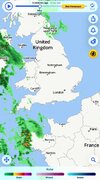
I use the satellite and weather radar apps, they seem to use data from Meteoradar. Recently some patches of precipitation have been shown in pink. Having regard to their position and the season, I think pink probably means snow. Annoyingly, however, I have not been able to find a key or guide that actually says so.
Does anyone know?
 www.meteoradar.co.uk
Does anyone know?
Rain radar Europe – Current rainfall & showers | Meteoradar
See the current rainfall on the rain radar for Europe at Meteoradar. ✅ Shower Radar ✅ Daily weather report
www.meteoradar.co.uk