Not entirely true as planing allows them to go faster for HP used providing they can get to a speed that allows them to plane.
The speed increase for more power on a none planing boat is a lot less efficient. Simple physics say speed will increase.
Based on what I have seen but dependent on where a boat is used inshore a none planing boat needs ~10hp. At 4 or 5 it could need a tow due to tides. That in itself disproves the "theory".
My limited understanding of boat design tells me it's more about hull design, and loading of the boat that allows a boat to plane.
I've had a couple of people at the bow jumping up and down to get a boat that theoretically will plane, but was underpowered.
As I understand it, surprisingly, you do need some weight in the bows to get the boat to plane.
You need down trim once planing to maintain it. Putting weight on the bow has a similar effect if you don't have trim tabs. This is mainly to keep the prop driving you forward and keep the hull stable. The home made rubber boats in use to cross the channel are displacement boats with flat bottoms. Fully loaded it will never plane like a RIB would, irrelevant of power.
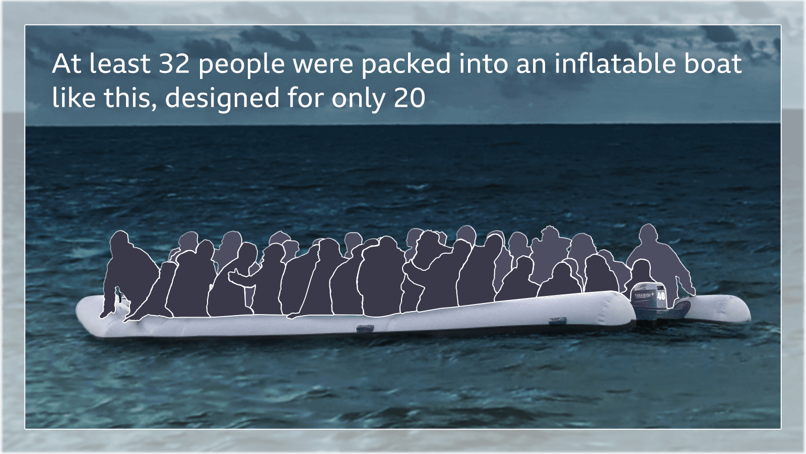
We know when they were found and where they were found. The impact of the tidal stream, entirely depends on when propulsion failed and if they had more ebbs than floods. From the photos of the "dingy", and reports it was DIY 10m inflatable with flimsy PVC pontoons and no reinforcement anywhere. 2.3 tonnes of human cargo squeezed into/onto that.
I've produced two models, with propulsion failure around midnight and the other 2-3 hours later. The shorter model shows they would have been pushed slightly towards UK waters. The longer shows no more than 1-2 cables SW.
We also have the recorded mayday relay from cap gris-nez, who were coordinating the rescue. If this was the genuine full message its highly unusual.
It is normal for a mayday relay to give a location or last known position and time. This is essential for any SARs operation.
From location of the survivors at the time of pickup, you can plot their approx position by each hour back.
Dover <M> tidal stream (the closest to their known position).
Given it was roughly 80% of a spring tide, the NW/SE turn points last barely 15 minutes before / after each slack tide and these are the peak flows.
If they lost propulsion before midnight, they will have been pushed back 0.1-0.2 NM Maximum. If they lost it later, the tide would take them slightly closer to the UK.
Who's to blame:
Traffickers - boat was massively overloaded and highly unlikely to be safe for 34 people.
Adult Migrants themselves - You don't have to be an expert in boats to know that 34 people in a home made boat in cold water attempting to cross 20-30 miles at night is stupid.
Coordinating rescuers - might have some learning, based on the mayday relay. But then if the Illegals were fibbing about their location, how the hell can someone successfully search for them?
The argument that French rescuers were busy and UK weren't is nonsense. This is one of busiest shipping lanes in the world. Standard procedure is to task local vessels. Based on the Mayday relay they had no idea where the MOBs were to task anyone.
However, once you say ""All ships in this area are requested to have a sharp lookout to proceed to this area to take contact and report any information to Gris-Nez emergency coordinating this operation." You are in charge.
Rather than itemise your comments, as I would normally, I'll respond to the whole.
Yes, we know where they were found, and when they were found, about 9 nautical miles from Calais, and at that point the dividing line is only about 10 nautical miles, so they were about 1 nautical mile inside French waters. from previous estimations, we can assume that they were under way from about 20.00 hrs Evening of 23rd) until about 01.30 hrs, (morning of 24th) some 5.5 hours. We have a report that they first called for assistance at 01.30, but they were still underway.
There is no report at all, that power was lost at about midnight, so your model is solely your creation. There is a report that they were still under power at 01.30hrs.
You previously estimated their journey to be about 40 nautical miles from Dunkerque. Sailing at about 5 knots (your assumption) for 5.5 hours would give their position in British waters, NW of Calais, about 27.5 nautical miles into their journey. For sure there would be some wind and tide influence, but I think we can safely assume that they reached British waters, NW of Calais.
See diagram with black spot showing midpoint of journey, i.e. 20 nautical miles. (47 miles is about 40 nautical miles) red cross indicates approximate boat position. The faint grey line indicates the dividing line.
What we also know is that they left at about 20.00 hrs British time, coincidentally around low water point, for Dover, so low water for Calais or Dunkerque would be an hour or so later.
We know from previous discussions that the tide in the Channel does not flow back and fore between UK and France.
It flows in a NE, SW direction, and the tide time between places in UK and France are about 1.5 hours difference. France being slightly later than UK.
Dover Tide Times - free 7 day tide predictions for Dover with historic high and low tides, sunrise, sunset and phases of the moon
www.tidetimes.org.uk
So there was a flood tide in the Channel with water flowing in a NE direction, but this flood tide would only start to affect them around 1.5hours before high water, i.e. around midnight until about 05.00hrs in the morning of the 24th.
The 'Dover Strait' is a narrow area of water between the English Channel and the North Sea. The water flows in from the English Channel for approximately 6 hours on the FLOOD TIDE to spread out in the North Sea, then stops, turns around through 180°, and flows back from the North Sea for approximately 6.5 hours on the EBB TIDE to spread out in the English Channel (imagine the old fashioned hour glass with the sand flowing through the restriction in the middle). As an approximate guide we can say that, at Dover:
The FLOOD TIDE flows from the South West from 1.5 hours before HIGH WATER to 4 hours after HIGH WATER DOVER (followed by a short period of 'Slack' water).
The EBB TIDE flows from the North East from 4.5 hours after HIGH WATER to 2 hours before HIGH WATER DOVER (followed by a short period of 'Slack' water).
A chart and satellite map of the Dover Strait where channel swimmers cross.
www.queenofthechannel.com
Then they were subjected to the reverse ebb tide, about 4.5 hours after high water (about 05.00hrs) until about 2 hours before the next high water, ( about 11.30hrs) Then they would have been subject to the flood tide from about noon on the 24th, until about 17.00hrs on the 24th. But they were found at about 14.00hrs, before the flood tide had affected them as much as the ebb tide had.
So it's perfectly possible that the ebb tide could have taken them closer, and back into French waters.
In addition there was a northerly wind blowing, which, if it had any effect, would have blown them toward the French coast.
Therefore it's perfectly feasible that they made it to British waters, just, and the tide and wind caused them to drift and be blown back toward the French coast.
But, as I said, it's probably marginal, but that does not excuse either SAR service launching a rescue attempt.
We know when they were found and where they were found. The impact of the tidal stream, entirely depends on when propulsion failed and if they had more ebbs than floods. From the photos of the "dingy", and reports it was DIY 10m inflatable with flimsy PVC pontoons and no reinforcement anywhere. 2.3 tonnes of human cargo squeezed into/onto that.
I've produced two models, with propulsion failure around midnight and the other 2-3 hours later. The shorter model shows they would have been pushed slightly towards UK waters. The longer shows no more than 1-2 cables SW.
We also have the recorded mayday relay from cap gris-nez, who were coordinating the rescue. If this was the genuine full message its highly unusual.
It is normal for a mayday relay to give a location or last known position and time. This is essential for any SARs operation.
From location of the survivors at the time of pickup, you can plot their approx position by each hour back.
Dover <M> tidal stream (the closest to their known position).
Given it was roughly 80% of a spring tide, the NW/SE turn points last barely 15 minutes before / after each slack tide and these are the peak flows.
If they lost propulsion before midnight, they will have been pushed back 0.1-0.2 NM Maximum. If they lost it later, the tide would take them slightly closer to the UK.
Who's to blame:
Traffickers - boat was massively overloaded and highly unlikely to be safe for 34 people.
Adult Migrants themselves - You don't have to be an expert in boats to know that 34 people in a home made boat in cold water attempting to cross 20-30 miles at night is stupid.
Coordinating rescuers - might have some learning, based on the mayday relay. But then if the Illegals were fibbing about their location, how the hell can someone successfully search for them?
The argument that French rescuers were busy and UK weren't is nonsense. This is one of busiest shipping lanes in the world. Standard procedure is to task local vessels. Based on the Mayday relay they had no idea where the MOBs were to task anyone.
However, once you say ""All ships in this area are requested to have a sharp lookout to proceed to this area to take contact and report any information to Gris-Nez emergency coordinating this operation." You are in charge.
@Pat ex you need to look at the direction of the flood and ebbs and make sure you are using standard port (I think you are now). I'posted them in no 417 straight out of Navionics, so adjusted for the 80% Spring.
The ebb and flood run along a transit pretty much parallel to the boundary line. They don't move things close or further away from the line as they travel SW/NE. There is a slight movement towards the UK, but its marginal. If we are now working on the idea that they were still going strong at 0130UTC and were rescued/found at 1230UTC (1:30pm French time) then the only tide stream that could have moved them any closer to France was the one which occurred just (20 mins) after slack water which was 1152UTC. around 15 mins before they were found. The affect of that tide is no more than 1 cable in terms of being closer or further away from the UK. They would have been around 2Nm further NE than where they 'sank'
The ebb and flood run along a transit pretty much parallel to the boundary line. They don't move things close or further away from the line as they travel SW/NE.
Unless there is a spillway effect., where the water flows through a narrow throat., and disperses into a wider area, giving the effect of a sideways influence.
The 'Dover Strait' is a narrow area of water between the English Channel and the North Sea. The water flows in from the English Channel for approximately 6 hours on the FLOOD TIDE to spread out in the North Sea, then stops, turns around through 180°, and flows back from the North Sea for approximately 6.5 hours on the EBB TIDE to spread out in the English Channel (imagine the old fashioned hour glass with the sand flowing through the restriction in the middle).
The tidal stream references account for this. The article in your link is a rough guide for those who don't have access to or don't know how to use more accurate tidal stream data.
The tidal stream references account for this. The article in your link is a rough guide for those who don't have access to or don't know how to use more accurate tidal stream data.
I'm sure the official investigation do have access to such data, and I'm sure they'll use it without your persistent social media campaign to blame the French.
I blame the traffickers and the illegal immigrants. Nobody is owed a guarantee to be rescued if they set off in a dangerous vessel in hazardous conditions.
I blame the traffickers and the illegal immigrants. Nobody is owed a guarantee to be rescued if they set off in a dangerous vessel in hazardous conditions.
Of course you do, you've made that obvious frequently.
I blame the arms manufacturers and merchants first, for providing the means for countries to instigate and perpetuate conflict.
Then I blame the nations as a group for failing to come up with a plan to accommodate refugees in a fair and just way.
Then I blame the individual nations for refusing to create a safe and legal route for refugees.
Then i blame the governments for exploiting the presence of refugees to blame for their own shortcomings.
Then I blame the selfish xenophobes for displaying such inhumane and unsympathetic attitudes to refugees.
Then I blame individuals for fomenting hatred against refugees.
But given the current trajectory of climate change, what goes around may well come around.
You assume that everyone in the world has peaceful intent and that everyone in the world can be equally as wealthy, looked after, fed etc and nobody sets about wanting to invade their neighbour or destroy them based on their beliefs, the desire for power or just jealousy.
You assume that everyone in the world has peaceful intent and that everyone in the world can be equally as wealthy, looked after, fed etc and nobody sets about wanting to invade their neighbour or destroy them based on their beliefs, the desire for power or just jealousy.
I suspect that anyone intent on harming anyone else would not resort to camping out in Calais for months, then crossing the Channel in a dinghy, to claim asylum and be detained and questioned rigorously.